Bob McDavitt’s ideas for sailing around the South Pacific.
Disclaimer: Weather is a mix of pattern and chaos; these ideas are from the patterned world.
Compiled Sunday 24 March 2024
Saturday 23 March 2024 was World Meteorological Day.
The theme this year is AT THE FRONTLINE OF CLIMATE CHANGE
They have just completed a report of the state of the climate at the end of 2023

This can be seen at youtu.be/ES7eKWRRJ0o
The report starts with the alarming record breaking of a warming planet but ends with the hope of rapidly increasing sustainable energy sources, reducing emissions, and increasing investment in climate adaptation.
TROPICS
The latest cyclone activity report is at zoom.earth and tropic.ssec.wisc.edu and Tropical Cyclone Potential is from www.ssd.noaa.gov/PS/TROP/TCFP/index.html

Late reports from Mozambique say Tropical Storm Filipo killed one person and injured seven others when it passed through the south of the country during the previous week.
• Category-2 Cyclone Megan swamped a remote part of far northern Australia, along the coast of the Gulf of Carpentaria.
• Tropical Storm Neville strengthened to hurricane force over the eastern Indian Ocean.
The MJO pattern moved over the South Pacific last week and is still around this week, but nothing much has been triggered. We can now expect a few quiet weeks in the tropical South Pacific, and there is still time for another MJO cycle in mid-April before ethe normal end of this cyclone season.
WEATHER ZONES
Weather Zones Mid-week GFS model showing isobars, winds, waves (purple), rain (red), MT (Monsoonal trough), STR (Subtropical Ridge), SPCZ (South Pacific Convergence Zone) CZ (Convergence Zone)

Rain Accumulation next five days from windy.com
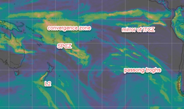
The South Pacific Convergence zone is starting to weaken and narrow and stretches from Coral Sea to north of Vanuatu and across Fiji and southern Tonga. Tropical Low L1 should travel off to the southeast and take with it much of the SPCZ energy.
There is another convergence zone this week between Tuvalu and Tokelau/Suwarrow, and a “mirror ITCZ” along around 3 to 7S between Galapagos and Marquesas.
HIGHS and LOWS
HIGH H1 is expected to travel eastwards along around 40S and well south of Tahiti.
LOW L2 is expected to travel quickly eastwards across south Tasman Sea along 50S next few days and bring strong west to SW winds over central and southern NZ mid-week.
This is expected to quickly be followed by L3 travelling NE from Southern Ocean along east-of -NZ on Good Friday and then deepening east of the NI over the Easter weekend, moving off early next week. Avoid.
Panama to Marquesas:
The northerly winds in Panama gulf are expected to return from around Sat 30 March for a few days… try and arrange departure then. .
>>>>>>>>>>>>>>>>>>>>>>>>>>>>>>>>>>>
If you would like more details about your voyage, then check metbob.com to see what I offer.
Or Facebook at /www.facebook.com/metbobnz/
Weathergram with graphics is at metbob.wordpress.com (subscribe/unsubscribe at bottom).
Weathergram archive (with translator) is at weathergram.blogspot.co.nz.
Contact is bob@metbob.com or text 64277762212.
>>>>>>>>>>>>>>>>>>>>>>>>>>>>>>>>>>>>>

Bob,
Greetings from Sydney Harbour,
<
div>I was hoping th
Hi Michael
Your comment got cut off… maybe send to bob@metbob.com
Bob