WEATHERGRAM
YOTREPS
Compiled Sun 17 Feb 2019
Bob McDavitt’s ideas for sailing around the South Pacific.
Disclaimer: Weather is a mix of pattern and chaos; these ideas are from the patterned world.
SEA ROUGHNESS
The Beaufort Scale was developed by the Irish Royal Naval Officer Francis Beaufort in 1805, and first used on HMS Beagle. as an empirical measure that related wind speed to the observed conditions over an ocean (not near a shore). The story goes that in those days a British Man-of-War could carry 12 sails, which is why the Beaufort scale goes from 1 to 12 (plus 0, for no wind).
From the Beaufort Scale, for a given wind speed, the height of the resulting waves offshore for a fully developed sea are given. But the impact of waves on navigation depends on the size of the vessel and factors such as the wave period, the water depth, and swells from other directions. Also, larger waves need time and distance to develop, so the wave fetch is big factor.
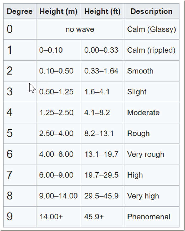
After World War One, in the 1920s, the first SHIP weather reporting code was being developed, and just one character was set aside to report the “state of the sea” and another for the “state of the swell”. Captain H.P Douglas (later Vice Admiral Sir Percy Douglas and hydrographer of the Royal Navy) devised two ten-point scales to do this. These scales estimate the roughness of the sea and the swell for navigation.
The Douglas scale for the “state of the sea” (Wind waves) is as follows:
\Interestingly, It is almost linearly related to the square root of the wave height
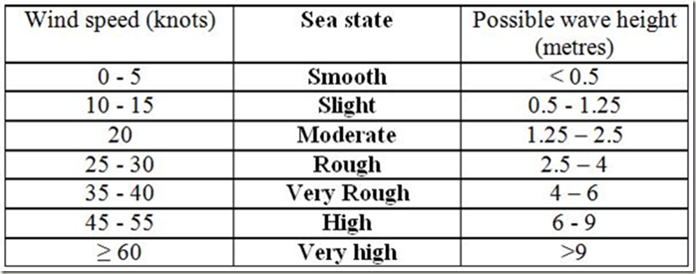
MetService forecasts give the wind speed to the nearest 5knots. MetService uses the following Sea State guide, based on the Douglas and Beaufort Scales, relating wind speed, sea state and probable wave height:
Note that sea state given in the MetService marine forecast is the maximum possible state for that wind speed. So, if the forecast is for 25 knots, then the seas will be forecast to be rough, but may actually be smooth or slight within places of limited fetch such as the harbour.
For a more detailed discussion on this see the MetService blog at
blog.metservice.com/sea-state-and-swell
When it comes to working out the likely Height H and Period P of swell waves, the main chart used by marine meteorologists is the Bretschneider nomogram (1970) which, based on climatological observations, gives what waves result from agiven wind + fetch + duration. Examples of this are given in that MetService blog.
The Bretschneider normogram does NOT tell us much about the roughness/steepness of swell.
Looking at the cruising forums, there seems to be some agreement that wave Period affects the roughness of the swell
http://www.cruisersforum.com/forums/f90/wave-height-period-wind-speed-comfort-116480.html
http://www.cruisersforum.com/forums/f90/how-to-estimate-roughness-of-sea-206263-2.html
In summary, If P in seconds is 1.33 or more times H in feet then waves are manageable. Any shorter a period and the waves are too rough.
We use metres, so that translates to if P in seconds is more than a ratio of 4.4 times the H in metres then waves are OK. I think that perhaps a simple factor of 4 may be a better pick, so a 2m swell is manageable if its period is 8 Seconds or more, and a 3m swell is manageable if its period is 12 seconds or more. However, this is just a rule of thumb that kind-of works for mid-range waves,
I came across an article at widecanvas.weebly.com/nature/waves-height-period-and-length
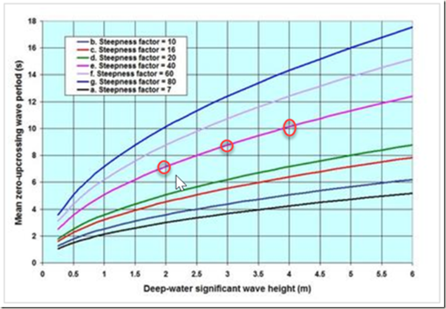
And here Dr. Dilip Barua offers us a graph which shows 7 roughness or comfort curves and how they sort out with swell given in Significant height in metres and Period in seconds for what he calls “longshore waves” .
Basically, the magenta roughness curve is close enough to acceptable comfort. It isn’t a straight line, but at H= 2m height is around P=7 seconds period (ratio of 3.5) and at 3m height it is near 9 seconds (ratio of 3) and at 4m it is at 10 seconds (ratio of 2.5). The suggestion from this graph is that maybe the ratio between H and P for acceptable waves is not linear, and maybe it drops for the higher waves. I think this relationship requires more research.
=-=-=-=-=-=-=-=-=-=-=-=-=-=-=-=-=-=-=-=-=-=-=-=-=-=-=
THE TROPICS
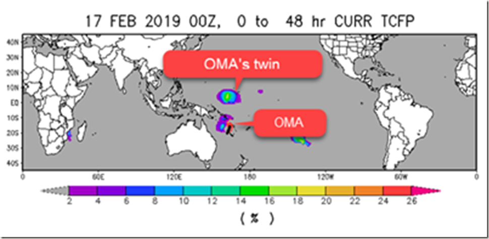
Latest cyclone activity as at tropic.ssec.wisc.edu and TCFP tropical Cyclone Formation Potential as seen at www.ssd.noaa.gov/PS/TROP/TCFP/index.html
There is still a monsoonal trough stretching from the Coral Sea /TC OMA across Fiji to another tropical Low located south of French Polynesia. TC OMA is expect to slowly drift southwest across NW parts of New Caledonia and then curve southwards into the Tasman Sea. When it reaches 30S I expect it to encounter stronger WNW winds aloft that may knock off its top clouds and start its spin-down, or perhaps shunt the whole system east-southeast across northern NZ—ah well, we need the rain, and the surfers may get some interesting swells. The models still haven’t latched onto this system and are offering different scenarios, and at this stage a wide variety of outcomes are still possible, so get updates.
An interesting meteorological is very likely to soon occur north of OMA. The near-equatorial westerly winds are expected to help spin-up another tropical cyclone north of the equator which will have a life of its own. This is called “cyclone twinning”, but in this case the spin-up is likely to occur when OMA is near 15S , and usually it occurs when the starter cyclone is a 5 to 10S.
There are tropical depressions spaced out along this monsoonal trough, and there is a good chance that at least one of these may deepen into a tropical cyclone this week, but the models are having problems resolving the details, so it seems best to avoid sailing in this region for the coming week.
OMA is likely to peak on Tuesday night /Wednesday near 22S, s Cat 3 maybe 4.
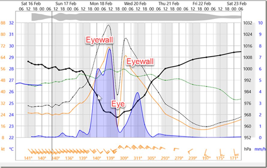
Here is what the GFS model shows as a meteogram for 22S over the next few days, offering a good view of what may happen to wind (orange), gusts (black-dots), temperature (green/blue), pressure (black) and rain (blue shading) as a cyclone passes. This shows the “eye” and the “eye-wall”. A minimum of 967hPa and peak gust of 87 knots is worthy of respect.
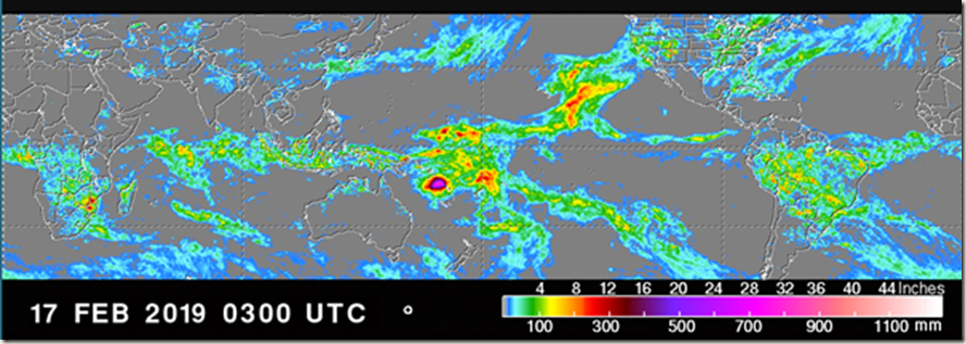
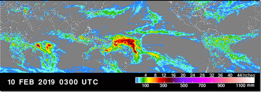
The weekly rain maps for the past 2 weeks clearly shows this monsoonal trough weakening and the slow path so far of an intensifying TC OMA
See trmm.gsfc.nasa.gov/trmm_rain/Events/big_global_accumlation.gif
WEATHER ZONES
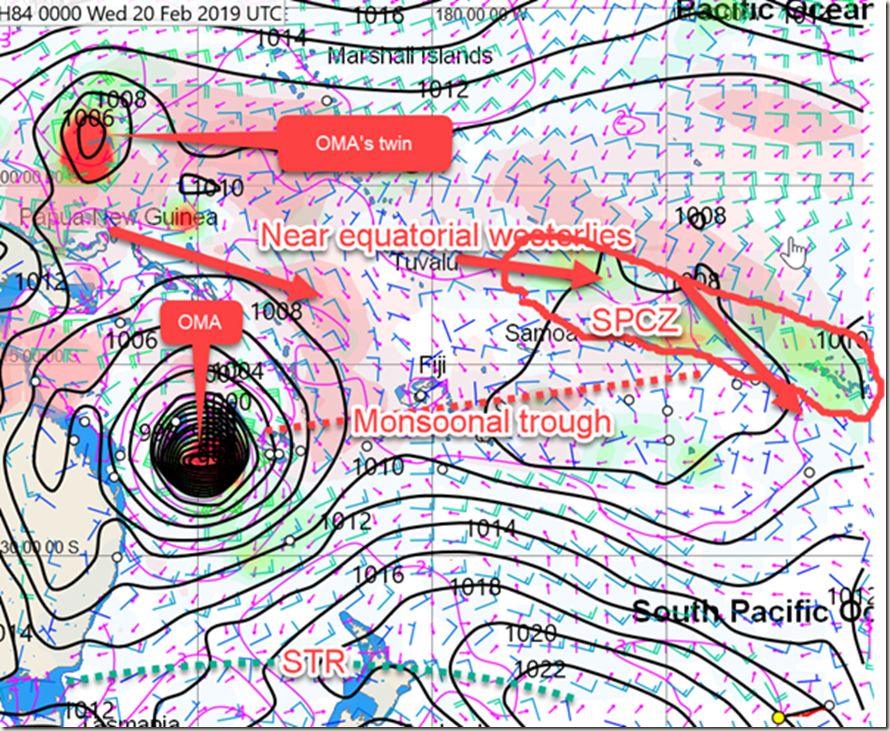
Weather Zones (see text) as expected Tuesday 00UTC showing isobars, winds, Monsoonal trough, OMA and it’s twin, waves(magenta) STR, and SPCZ. Pink area = lightning likely (high CAPE)
SPCZ=South Pacific Convergence zone.
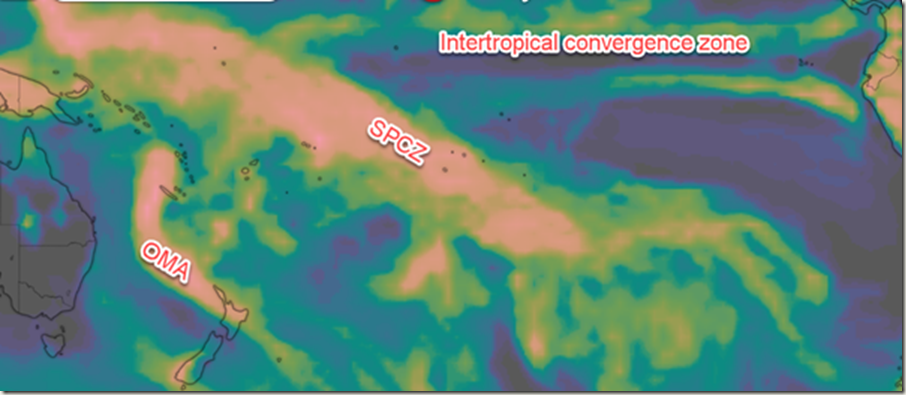
The SPCZ is on the northeastern edge of the monsoonal trough ,and likely to stretch from Samoa to French Polynesia this week.
Accumulated rainfall for next week from windyty.com. CZ= convergence zone.
Subtropical ridge (STR)
HIGH is travelling east across central NZ next few days and then further east along 40S.
Next HIGH is further south and likely to travel east across Tasmania and into South Tasman sea around Sat/Sun 2/24 Feb
Australia/Tasman Sea / New Zealand
Wait until after TC OMA.
Panama to Marquesas
Only light winds for starters over next few days, but a reasonable northerly wind is expected next week, so may as well stay put this week.
Port Vallarta to Marquesas
There may be a few days of light winds for starters, and then looks Ok with a departure on Tuesday to Thursday, and then some more light winds until Saturday. ITCZ likely between 5N and 2N, and there may be a “mirror CZ” near 3 to 4S
>>>>>>>>>>>>>>>>>>>>>>>>>>>>>>>>>>>>>>>>>>>>>>>>>>>>>>>
If you would like more detail for your voyage, then check metbob.com to see what I offer.
Or Facebook at /www.facebook.com/metbobnz/
Weathergram with graphics is at metbob.wordpress.com (subscribe/unsubscribe at bottom).
Weathergram archive (with translator) is at weathergram.blogspot.co.nz.
Contact is bob@metbob.com or txt 6427 7762212
>>>>>>>>>>>>>>>>>>>>>>>>>>>>>>>>>>>>>>>>>>>>>>>>>>
Leave a comment